Social Geography
Versatile Everyday Emotion Mapping (VEEM)
lesson plan
PDF

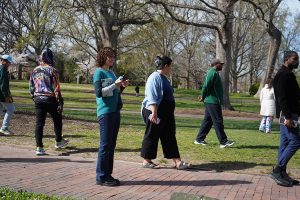
Our mapping practices offer an invitation to reflect on the rich geographies introduced through To Drink From the Well, the Black and Carolina Blue Tour, the Eclipse performance, and oral histories from the Jackson Center of Northside residents. In the spring of 2023, a collective of students, artists, and residents steeped in this material took a slow and intentional walk through campus. Participants reflected on these different ways of knowing the campus to create maps that tell different stories than what a traditional visitor guide to UNC might reveal. As discussed in part 1 of the blog series, the maps not only represent the buildings and environment they moved through and how they felt throughout the walk.
This mapping practice, which we call, Versatile Everyday Emotion Mapping (VEEM), offers flexible, diverse, and creative approaches toward data, enabling the collective of students, artists and residents to make their own choices of ‘how to represent’ their emotions and relations to campus spaces. Participants are instructed that there is no right or wrong way to make a map; and are invited to think creatively and expansively, with access to colored markers (or ipad sketch features) to create a sketch map or draw on a GPS-created map. This flexibility allows participants to play, discover, and control what they reveal through the maps, and represent the unexpected insights into campus contexts, histories, and identities that come from ‘noticing’ or attuning to space through the slow walk.
Context, personal narration, trust, and vulnerability are crucial to understanding these maps. Each map is crafted based on intimate relation to space, to the people and buildings encountered on the walk, so interviews or small group discussion between the walk participants helps open up an analysis of the map. Show-and-tell practices and reciprocal listening, reflecting with open-ended questions, and sharing between map makers deepen the understanding of the map. Analyzing the collection of maps does not need to be a comparative process across maps. But participants can consider how different people feel in the same spaces, and how the maps show a deeper understanding of shared space, history, and futures when brought together across the participants.
Broader level analysis can occur via dynamic qualitative coding software like Nvivo or through hand coding common themes, ideas, or takeaways that emerge from the combination of map creation and discussion of the map. Rather than resulting in a cacophony of incongruous data, we find that the flexibility of the approach enhances our understanding of people’s emotions and experiences of the campus landscape.
Lesson plan by Leiha Edmonds